Tag Archives: Arapahoe

Waterview Traffic on and off Arapahoe Avenue

One of the big concerns that usually comes up for new building projects is what it will do to traffic. Zocalo’s Waterview project plans make cars less prominent on the site itself. But in spite of the best intentions of the plans, people in the area are concerned about how the project will affect traffic on Arapahoe Avenue. Will it cause more snarl-ups and delays during rush hour?

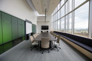
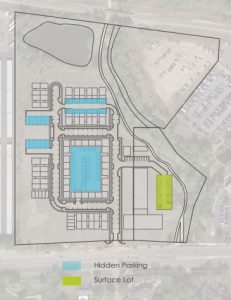
There will be 215 parking spaces in a parking building. Add another 180 parking spaces will be hidden inside or underneath various buildings. The picture shows where the parking spaces will be.

Parking and traffic at Waterview
Parking spaces at Waterview

The problem is that all those cars will all be going in and out of Waterview at the same point on Arapahoe. That means more cars involved in local traffic on that already congested Avenue.

According to Zacolo’s documents at the Boulder Planning and Development website, “During the morning peak-hour, . . , about 62 vehicles would enter and about 138 vehicles would exit the site. During the afternoon peak-hour, . . . , about 139 vehicles would enter and about 89 vehicles would exit the site.”

Zacolo figures that about 20% of traffic will be absorbed by bus, bike, and walking  options. The bus stops on Arapahoe Road are about 150 feet west and 0.15 miles east of the site. Both sides of Arapahoe Avenue have sidewalks and bike lanes. Waterview will have a path along the creek for walkers and bikers and an on-site bike share and car share station.

So, the hope is that the increase in traffic won’t be as big because more people will bus, bike, or walk instead of driving where they need to go.

Zocalo wants to help with Boulder City’s transportation and climate goals for East Arapahoe. Including transit options to people who live, shop, and work at Waterview could help meet those goals.

We don’t know yet what the overall effect will be on residents and businesses that are already in Arapahoe Ridge. We will keep you updated on how this project moves through the system.

Boulder News: Arapahoe Ridge ‘Rock’ Park Renovation

A renovation effort put forth by the Parks and Recreation Department began on May 1st of this year ‘Rock’ Park in Arapahoe Ridge.  The aim of this renovation is to improve the park as a whole by installing new infrastructure and upgrading playground equipment to meet current standards.  The project has just begun, but is scheduled to be completed by the fall of this year.

The first step in this renovation project is the removal and pruning of trees in the park and by public streets.  By removing any potential obstructions beforehand, the installation of new infrastructure is expected to go much smoother.  This also keeps the park from being closed at a later date, and is most cost effective.

Along with pruning for tree health, one notable tree in Arapahoe Ridge will be removed.  An Ash tree has become infested with Emerald Ash Borer, and will be removed to keep the infestation from spreading.

The park itself is not going to be closed off to the public during the renovation period, however.  The city has stated that they will make an effort to keep their impact low, although the public should be aware that some amenities may not be available during certain periods of the renovation.

The local community was integral in the planning phase of this renovation, with feedback on the rock structure itself being very strong.  With that in mind, the Parks Department moved forward with a plan that would have the least impact on the structure as possible.  The plan states that they will install a support to ensure the main cave area remain structurally sound over time, install a rubber surface to replace the pea gravel, and secure the boulders on the main structure through re-grouting.

Once complete, ‘Rock’ Park will be home to a brand new playground meant to highlight the rock structure the park is known for.  The Parks Department is also planning on hosting a celebration event for the completion of the project when that time arrives.  Further updates on the project can be found on the Arapahoe Ridge Park page on the city’s website.

Boulder News: East Edge

2017-03_BoNews

In December of 2016 a team of designers and developers volunteered their time for a technical advisory panel.  The goal of this panel, the Urban Land Institute Colorado (ULI Colorado) was to design a redevelopment plan for the area of East Boulder north of Arapahoe and west of 55th.  This 325 acre space is primarily used as an office park with some small industrial sites as well.  The panel was tasked by the Boulder Chamber and Boulder Area Realtor Association with seeing how this space could be used for more workforce housing. The panel took this request a step further.   They addressed a complete overhaul of the area, rather than just focusing on housing.    Their vision of this new hub of creativity would be called East Edge.  Linked with new transportation options, East Edge would be broken into three districts that mix residential and commercial use.  Existing business would continue being supported and add new ones as well.  The idea being that each of the businesses within each district would be within walking distance.  This more ambitious and extreme plan is not what many current residents had in mind.  A large scale expansion is seen by many as inconsistent their own vision for their neighborhood.  However, there are some potential benefits in this plan worth considering which may influence public opinion.

This panel envisions East Edge as a “creativity hub”.  ULI Colorado hopes to encourage the growth of new jobs here as well as housing, services, and transportation growth. .  They envision transition from an office park to a more multi-use neighborhood.

One challenge to East Edge’s redevelopment plan is in zoning.  The panel suggests that the city allow them to go beyond the current 55ft height limit in place (up to 90ft in some areas).  This would allow for residential and retail services in the same space.  Additionally, office buildings could have shops on the ground level.  Because of the area’s low ground level relative to the rest of Boulder the panel believes the view shed would not be harmed.

Another concern ULI Colorado has for East Edge, and all potential development plans, is flooding.  The entire area is located within a floodplain, and said to be in need of mitigation.  The panel suggests that the Flatiron Golf course be used for mitigation before moving forward.

The top priority of the East Edge plan is to begin by redeveloping the land between Arapahoe and the BNSF rail corridor.  This land would become one of the mixed-use neighborhoods for residential and commercial space with an interior main street.  This would have the advantage of much safer pedestrian and bike traffic.  But this is just one of many steps and details outlined for East Edge.  The entire plan is available for all citizens to see on the better boulder website, and are encouraged to do so.

Neighborhood Spotlight: Ridglea Hills

The scenic and beautiful neighborhood of Ridglea Hills lies up in the hills of East Boulder. The view of the neighborhood is second only to the view of the Flatirons Built as it sits on the hills above Baseline Reservoir.  There is no view quite like overlooking the Baseline Reservoir anywhere else in Boulder.  Ridglea Hills is one of the most unique neighborhoods around with a range of homes from modern designs to proven classics built as early as the 60’s.

Getting Around

Transportation

Ridglea Hills sits in a very comfortable place in terms of transportation.  Placed right between Baseline and Arapahoe with a straight shot to South Boulder, no commute will be a chore.  Baseline is right on the RTD’s bus line which goes to multiple schools on its way into downtown, making it perfect for anyone.

Biking

Baseline’s long stretches of uninterrupted road are a big draw for many road bikers for both transportation and recreation.  There are plenty of dedicated bike trails just a short ride away through the quiet neighborhoods.  Bobolink trail and the Dry Creek trail are just two right in the neighborhood.  Also, being right beside a school zone has made it safe for riders of all ages.

Neighborhood Amenities

Ridglea Hills offers the views and feel of a secluded neighborhood without the downside of being far from all the amenities found in town.  There are an abundance of hiking and biking trails right in the neighborhood offering even more breathtaking views.  The East Boulder Rec Center is just around the corner.  The Baseline Reservoir is right across the street to members for water sports.  The Flatiron Golf course also just down a few block on Arapahoe.

The Ridglea Hills neighborhood offers plenty of shopping choices.  The Meadows Shopping center is just down Baseline with a Safeway, Michael’s, and a handful of places to eat.  Arapahoe offers just as much without going much further.  A few shopping centers just West of 55th offer a handful of good restaurants, bike shop, thrift store, record store, and BDT (formerly Boulder Dinner Theater). But in either case, there’s nothing out of reach of this neighborhood.


Ridglea Hills in a Nutshell

Equal parts breathtaking views and great location, Ridglea Hills has it all.  Active individuals will love the proximity to local trails and the Rec Center.  Students will love the bus routes that make trips to school a breeze.  And adults will love how easy it is to get in and out of town for work and play.  Ridglea Hills has all the benefits of living away from a busy city center and none of the downsides.  At its heart, Ridglea Hills a tight community that represents the best of what Boulder has to offer.

Boulder News: Envisioning East Arapahoe

conference-room

Envisioning East Arapahoe has found its way back to the city’s agenda after being shelved for two years.  Three main scenarios were created considering different goals and predictions of how the neighborhood will look in the future.

Scenario A is termed “Current Trends.”  This scenario assumes East Arapahoe will continue having small industry, with few opportunities for new office or retail space.  Additional residential buildings would be less likely to be built.  In short, scenario A plans for the least change to our neighborhood.

Scenario B is termed “Districts.”  Walnut East would extend to meet 48th St north Boulder Community Hospital with more medical related offices and possibly retail.  The area below Gerald Stazio ballfields would become “Recycling Row”.  Significant street alterations on Arapahoe including new intersections are planned to increase commuter throughput.  The Arapahoe alterations aim to facilitate transportation modalities.

Scenario C is termed “Housing Choices.”  Affordable housing is planned for between 55th & 63rd on Arapahoe.  New housing would be built within a 15 minute walk from nearby shops and places of work.  The BDT and surrounding grounds would become part of an “Art Center.”  This plan includes the highest level of street alterations.  New parks, community gardens, and public spaces are all planned for scenarios B & C.

The Transportation Plan is another aspect of the Envision East Arapahoe plan. This long term plan aims to increase all types of transportation on Arapahoe.  The plan supports the Boulder’s Transportation Master Plan and the increasing number of commuters from Boulder’s supporting communities.

These plans are likely the most impactful Boulder City intervention in our neighborhood in a long time.  Public meetings for these plans have not been set for the Envinsion East Arapahoe, so stay tuned.   The city has yet to confirm any details on Envision East Arapahoe plan, but there is a public meeting for the Transportation Plan on February 2, 2017.  The previous meeting was on December 5th.  Those who want to have their voices heard on these matters can contact Adam at adam@krollre.com to receive more details as they are available.